Mesmerizing 2026 Guide: Big Sur, California & the Wild Coast
Explore Big Sur, California in 2026: Highway 1 icons, redwoods, coastal fog, cliffside camps, whales, and honest tips for the wild coast.

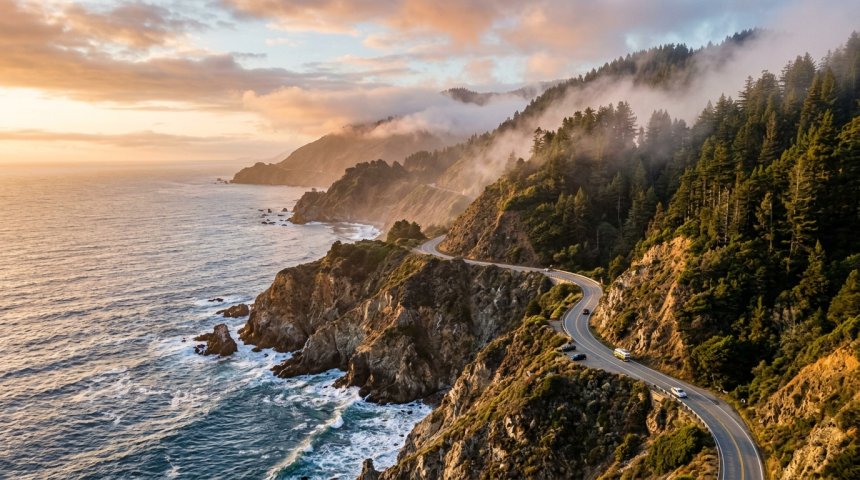
The fog was so thick north of Bixby Bridge that I was driving by faith and the white line, honestly a little annoyed, having planned this Big Sur trip for months and been handed what looked like a gray wall. Then, somewhere around a blind curve, the marine layer did the thing it does out here — it tore open without warning, like a curtain yanked sideways, and the coast appeared all at once: cliffs dropping eight hundred feet, the Pacific rolling in from forever, a hawk hanging in the gap where the fog had been. I pulled into the first turnout, got out, and didn't say anything for a long time. That's the thing nobody warns you about Big Sur. It's not that you'll run out of things to say. It's that the place regularly takes your voice away, and the silence it leaves behind is the actual product.
I've been back enough times since to have habits — a fog plan, a clear-sky plan, a campsite I dream about, a burger I think about in winter — and this guide is those habits written down honestly. Not a brochure. A friend's notes, with the mistakes included so you can skip them.
First, Understand What Big Sur Actually Is
Big Sur is not a town. People arrive expecting a downtown and find a ninety-ish mile stretch of coast with no center, no stoplights to speak of, and a population smaller than one city block. It's a region — roughly from Carmel's southern edge down toward San Simeon — held together by one thin, impossible road: Highway 1, carved into the cliffs in the 1930s, still one of the great driving roads on Earth.
That geography is the whole experience. There's no "walking around Big Sur." There's driving between miracles, pulling into turnouts, hiking up canyons where redwoods hide from the ocean, and stopping at a lodge or a roadside deck for a meal with a view that ruins other views for you. The pace is forced on you, and it's the best thing about it. Big Sur doesn't do itineraries. It does moments, spaced by curves.
And the weather is a character, not a backdrop. Fog rolls in and out on its own schedule. The light changes every twenty minutes. You will plan a sunset and get a cloud bank, and the cloud bank will be more beautiful than the sunset you planned. Come ready to negotiate with the sky.
Getting There (and the Highway 1 Reality Check)
Most people drive in from the north — Carmel and Monterey, about two hours south of San Francisco — or from the south via San Simeon and Cambria. The nearest real airports are Monterey, San Jose, and San Francisco. Rent a car. This is the least optional rental car in California; Big Sur has no trains, no useful buses, and rideshare out here is a rumor.
Now the honest part, because it has ruined real trips: Highway 1 in Big Sur slides, cracks, and closes more often than any famous road in America. Winter storms drop rockfalls; whole sections have shut for months. Before you plan anything, check the current Caltrans status for Highway 1 in Big Sur, and again the morning you drive, and keep a flexible heart. When it's open, drive it slowly, use turnouts to let locals pass (they tailgate slow drivers with love and zero patience), and never — ever — stop in a lane for a photo. The turnout twenty seconds ahead exists for the photo. People get hurt, and tickets written, for the mid-lane stop.
Field note: fill the gas tank in Carmel or Cambria before entering. Gas in Big Sur exists, is real, and is priced like it knows you have no options, because you don't.
When to Go: Fog, Gold, and Storms
Summer (June–August) is paradox season: warmest air, but the marine layer parks itself on the coast and whole mornings vanish in gray. By afternoon the fog usually burns off to brilliance, and summer evenings are magic. It's also the busiest — weekends turn every turnout into a negotiation.
Fall (September–November) is my pick and I'll defend it loudly. The fog gives up, the sky goes that hard California blue, the ocean is at its clearest, and after Labor Day the crowds thin to a respectful murmur. If you can choose any window, choose October.
Winter (December–February) is the dramatic one: storm fronts roll in like armies, waves detonate on the rocks, waterfalls run full, and gray whales migrate past the cliffs. It's also closure season on the highway and chilly at night — but an empty Big Sur after rain, with the light doing religious things, is the insider's secret.
Spring (March–May) brings wildflowers on the hillsides, full creeks, and migrating whales overlapping with newborn elephant seals down south. Windy, changeable, gorgeous.
How Long to Stay, and the Base-Camp Question
One day is a drive, not a trip — you'll see the icons through a windshield and remember traffic. Two nights is the minimum that counts, three is the sweet spot, and four lets the coast set your heartbeat. The classic mistake is trying to "do" Big Sur as a day loop from Monterey; the road doesn't reward rushing, and the good light lives at dawn and dusk, which is exactly when the day-tripper is stuck mid-highway.
Where to base? The region splits roughly into north (near the parks and Pfeiffer Beach), middle (Nepenthe, Fernwood, the river), and south (Lucia, Ragged Point). Pick one base and radiate, rather than hotel-hopping — the drives are short on the map and slow in reality. If your budget allows one splurge night of your life, this is the coast to spend it on; more on that below.
Getting Around: The Art of the Turnout
Driving is the activity, so get good at it. Keep the tank above half, the phone in the cupholder (there's no signal for most of the coast anyway — your phone becomes a camera and a paperweight, which is the healthiest thing that will happen to it all year), and your schedule loose. The etiquette is simple: turnouts are for stopping, lanes are not; uphill traffic has the right of way where the road narrows; and when a local tailgates you, pull over at the next wide spot and wave. They'll wave back. It's a small civilization with small manners, and they matter here.
Also: download offline maps the night before, screenshot your reservations (lodges and camps ask for confirmation at the gate when the network is down), and carry real paper or a downloaded list of your stops. The coast rewards the prepared and gently strands the optimistic.
The Icons, Done Right
Bixby Creek Bridge is the postcard — a 1930s concrete arch flung over a canyon, with the ocean stacked behind it. The honest tip: the famous photo is from the turnout on the north side before the bridge, not on the bridge itself, where stopping is illegal and dangerous. Go at morning light, or at dusk when the bridge goes silhouette, and accept that every photographer on Earth has stood exactly where you're standing, because it's the right place to stand.
McWay Falls is the tidefall — eighty feet of creek dropping straight onto a turquoise cove that's only a beach at low tide. The overlook walk in Julia Pfeiffer Burns State Park is short and easy, and the view stops conversation. The honest rules: parking fills by mid-morning (arrive early or after four), and going down to the cove is illegal, fined, and genuinely damaging — the beach has no public access on purpose. The overlook is the gift; take it.
Pfeiffer Beach is the strange one: sand tinged purple by manganese garnet, a keyhole arch that frames the surf, and waves that mean business. The access road is narrow and unmarked-ish (Sycamore Canyon Road), parking is tiny, and the water will drag you out if you get cute with it — this is a look-and-wander beach, not a swim beach. Sunset through the keyhole in winter is a photographer pilgrimage; go once for the purple sand and stay for the feeling that the coast is showing off.
Point Sur Lighthouse sits on its volcanic morro like a castle that missed its ocean exit. The volunteer-led tours (a few hours, some walking, some stairs) are the good kind of slow history — keepers' lives, shipwrecks, fog signals that shook the walls. Check the tour schedule before you plan around it; it runs on its own rhythm.
Nepenthe is not a viewpoint with a restaurant attached; it's a restaurant built as a viewpoint, perched eight hundred feet above the sea since the 1940s. Order the Ambrosia burger, sit on the terrace, and let an hour dissolve. Go mid-afternoon to dodge the lunch and sunset rushes, or embrace the sunset rush as a shared ritual — strangers become friendly when the light does that.
The Hikes: Redwoods on One Side, Ocean on the Other
Big Sur's hiking trick is that the canyons run perpendicular to the coast, so a single trail can hand you redwood shade, then oak hills, then a Pacific panorama, in one afternoon.
Ewoldsen Trail (Julia Pfeiffer Burns SP) is the greatest-hits loop: redwood canyon on the way in, ocean overlook on the way out, moderate effort, enormous payoff. Pfeiffer Falls and Valley View in Pfeiffer Big Sur State Park are the friendly classics — a waterfall under ferns, then a ridge view that explains the whole coastline. Partington Cove is the short, steep, strange one: a tunnel blasted through rock, a cove that once smuggled goods, and a sea view that feels discovered. Buzzards Roost out of Garrapata gives you the raw, cliff-top, wind-in-your-teeth version of Big Sur with fewer people. Tanbark Trail climbs hard out of the fog belt and regularly breaks through into sunshine above the marine layer, which is the closest hiking gets to ascending into heaven, in my experience.
The rules are the coast's rules: start early, carry water (creeks aren't trustworthy to drink), expect afternoon fog or wind, and turn around at your agreed time — the light on the drive back is part of the hike.
Wildlife: The Coast's Real Residents
Sea otters raft in the kelp beds — look for the brown commas floating on their backs. Gray whales spout past the cliffs December through April on their migration; humpbacks and, on lucky days, blue whales work the deeper water summer and fall. Sea lions haul out on the rocks and argue about it constantly. Down at the southern end near San Simeon, the Piedras Blancas elephant seal rookery is free, boardwalk-accessible, and absurd — two-ton animals piled on the sand like luggage, loudest in winter pupping season.
And the ghosts with wings: California condors, wingspans near ten feet, ride the thermals over the southern cliffs. Seeing one is a genuinely moving event — a prehistoric silhouette doing slow circles over a prehistoric coast. The etiquette is the same for all of it: distance, silence, no drones, no feeding, no approaching for the photo. You're visiting their house; act like it.
Eating on the Edge of the Continent
Big Sur dining is view-first and wallet-aware, and the hits are real. Nepenthe for the burger and the terrace, obviously. Big Sur Bakery for wood-fired bread, pastries, and a dinner that makes people plan trips around ovens. Big Sur River Inn for the riverside patio — burgers, a cold drink, your feet near the water, otters possible. Fernwood for the roadhouse soul: tacos, drinks, live music, string lights, the town's social center in a place with no town. Lucia Lodge for sourdough and a deck hanging over the Pacific at the coast's wilder end.
But here's my honest tip, the one locals nod at: some of the best meals on this coast cost fifteen dollars and come from a cooler. The picnic pullouts — especially the ones facing south over the coves — turn a grocery run in Carmel or Cambria into the finest dining room in California. Sandwich, apple, something warm in a thermos, and eight hundred feet of cliff. No reservation needed.
Field note: kitchens close early out here and cell service won't load the menu. Decide dinner by three p.m. like your grandparents did. It's good for you.
The Literary Soul: Why Writers Keep Coming Back
Big Sur has a myth layer. Henry Miller lived here for decades and wrote the coast into literature; the Henry Miller Memorial Library — part bookstore, part cultural clubhouse, part shrine — still hosts readings and remains the best rainy-hour stop on the coast. Jack Kerouac came looking for silence and wrote Big Sur about what the silence did to him. Beatniks, painters, and people fleeing noise have been washing up on this coast since the road opened, and the culture still carries that DNA: unplugged, slightly feral, allergic to hurry.
That's why the famous lodges here famously omit televisions and phones from the rooms. It's not a gimmick. It's the product. The first evening without a screen feels like withdrawal; the second feels like recovery; by the third you're reading a paperback on a deck at dusk and can't remember what the phone was for. Big Sur is one of the last places in America that enforces presence, and presence turns out to be the luxury people actually came for.
Where to Stay: From Treehouses to Tent Pads
The splurge of splurges: Post Ranch Inn — cliff houses and treehouses on stilts over the void, no TVs, no clocks, a spa, and the kind of silence you can hear. Ventana and Alila properties deliver resort luxury with canyon views. These are once-in-a-while money, and they're worth one while.
The storied middle: Deetjen's Big Sur Inn, a rambling 1930s bohemian lodge with creek sound and candlelight; Ripplewood and Big Sur Lodge for cabin-in-the-redwoods comfort; Fernwood's cabins if you want the roadhouse downstairs; Lucia Lodge and Ragged Point Inn for the cliff-hanging southern version.
The cheap-and-best: camping. Kirk Creek is the legend — oceanfront pads on the bluff, whales from your tent, sunsets that make strangers applaud. Pfeiffer Big Sur State Park puts you under redwoods by the river. Plaskett, Limekiln, and the environmental camps at Julia Pfeiffer Burns round out the list. Book on the state reservation system the moment windows open — Kirk Creek goes faster than concert tickets, and walk-up luck is a myth in season.
Field note: nights get genuinely cold even in summer, the marine layer drips everything, and fire rules are strict. Pack warmth, expect damp, and read the campfire policy twice.
Day Trips at the Edges
The coast's bookends are worth a half-day each. North: Point Lobos State Natural Reserve — the "crown jewel," cypress clinging to granite, sea lions bellowing in the coves, trails that feel curated by a god of composition. Go at opening; the lot fills by mid-morning. Beyond it, Carmel-by-the-Sea's storybook cottages and no-streetlights charm, and Monterey's Cannery Row and aquarium if weather turns. South: the elephant seals at Piedras Blancas, Hearst Castle's impossible hilltop if you book ahead, and Cambria's moonstone beaches for the gentle landing back into civilization.
Beating the Crowds (and the Fog)
Big Sur crowds are a weekend-and-summer phenomenon with a daily rhythm: turnouts and overlooks jam from ten to four, and empty out at dawn and dusk when the light is best anyway. So live at the edges of the day — sunrise at a cove, sunset at a terrace, midday for hiking up-canyon where the crowds physically can't follow you on a lunch break. Weekdays thin everything. Fall thins everything. And the fog, your other crowd: when the coast is gray, do what locals do — climb. The canyon trails rise above the marine layer within a couple of miles, and hiking out of a gray soup into a sunlit ocean panorama is the single most Big Sur experience there is.
Respect and Safety: The Coast Does Not Negotiate
This coastline kills a few people every year, almost always the same way: a back turned to the ocean for a photo, a cliff edge trusted that wasn't a trail, a wave that reached higher than the rock looked. Sneaker waves are real and fast. Stay behind rails, off closed trails, and facing the sea when near it. On the road: fog lights on, speed down, turnout for the tailgater. In the parks: pack out everything, no drones, fires only where allowed, and give wildlife their distance — especially condors, which are a conservation miracle and not a prop.
The deeper etiquette is quieter. Big Sur residents live with a fragile road, no cell towers by choice, and a landscape one storm from changing. The community chose slow on purpose. Be the visitor who matches it: buy local, tip the lodge staff like they carried your weekend on their backs (they did), and leave every turnout cleaner than the last person left it.
A Realistic Three-Day Plan
Day one (north to middle): arrive via Carmel, Point Lobos at opening if you're ambitious, Bixby photo at the turnout, lunch picnic at a pullout, check in, Ewoldsen or Pfeiffer Falls in the afternoon, sunset at Nepenthe's terrace or a bluff turnout, early night — the coast makes you sleepy in the good way. Day two: McWay Falls overlook early, Pfeiffer Beach mid-morning for the purple sand, bakery lunch, fog-plan hike (Tanbark) or beach wander, Henry Miller Library if it rains, Fernwood for dinner and music, stars or fog-drip from the cabin porch. Day three: drive the southern coast slow — Lucia, the condor cliffs, Ragged Point's gardens — elephant seals if you've got the stomach for the smell (worth it), then exit south or turn around and do it all backwards, because the coast is a different painting from the other direction and you already know the turnouts.
"Is Big Sur Worth the Hype?" — An Honest Answer
If your happy travel mode is nightlife, options, and a packed schedule, Big Sur will frustrate you: no signal, early kitchens, weather with opinions, and a road that demands patience. But if what you need is scale — the kind of landscape that recalibrates your sense of size and speed — there is nowhere like it in the lower forty-eight. It's not a beach vacation and not a road trip; it's a correction. The hype is real. The hype is also incomplete, because no photo carries the wind, the whale blow, or the particular silence after the fog tears open. You have to stand in it. That's the whole deal, and it's a good one.
FAQs
How many days do I need in Big Sur? Two nights minimum, three ideal. One day only ever shows you the windshield version. The coast rewards dawn and dusk, which day-trippers miss by definition.
When is the best time to go? September through November for clear skies and thin crowds; winter for storms, waterfalls, and whales if you accept closure risk; summer works if you plan around morning fog and weekend traffic.
Is there really no cell service? Mostly yes, really. Assume none, download maps and reservations, and tell someone your plan. People describe losing signal as annoying for the first hour and priceless by the second day.
Can I do Big Sur on a budget? Surprisingly yes: camping (book early), picnic lunches at the pullouts, free overlooks and beach walks, and one saved-up splurge meal. The best things — fog, light, whales, silence — are free.
Is it safe with kids? Very, with cliff discipline: rails mean rails, turnout stops only, and beaches for looking rather than swimming. The river patios, waterfall walks, and elephant seals are kid gold; the ocean itself is not a playground here.
What if Highway 1 is closed? Check Caltrans before and the morning of. If a section is shut, Big Sur becomes a one-end trip — do the north from Carmel or the south from Cambria, and save the full drive for the next visit. The coast doesn't mind being seen in halves.
What to Pack
Layers, always — the coast runs its own climate, ten degrees cooler than anywhere inland and damp when the fog leans in. A real jacket even in July, grippy shoes for canyon trails, water beyond reason, binoculars (whales, otters, condors — this is the single most regretted forgotten item), a headlamp, a paper map or offline maps, a cooler for the picnic that will outperform most restaurants, and one book you've been meaning to read for a year. The coast will finally give you the hours for it.
A Final Word
On my last evening of every Big Sur trip, I park at the same anonymous turnout south of the river, make terrible coffee from a thermos, and watch the light do its closing argument: gold on the headlands, then rose, then a blue that isn't quite night yet, while the surf keeps a beat older than every sentence I've written about it.
That's what this place is, in the end. Not a checklist — a scale model of your actual size, which is to say, small, and lucky, and briefly here. Big Sur doesn't ask you to believe anything or buy anything. It asks for your attention, for a couple of unhurried days, and it pays for that attention at a rate nothing else in California matches. Go. Drive slow. Stop at the turnouts, not in the lanes. Watch the fog tear open and don't reach for the phone first — the coast has been doing this show for a few million years, and it can hold you for ten more minutes before the camera gets its turn. And when it finally steals your voice, don't fight it. The silence is the souvenir.
Share
What's Your Reaction?
 Like
0
Like
0
 Dislike
0
Dislike
0
 Love
0
Love
0
 Funny
0
Funny
0
 Angry
0
Angry
0
 Sad
0
Sad
0
 Wow
0
Wow
0