Breathtaking 2026 Guide: Exploring Alaska Through Anchorage & Kenai
Exploring Alaska through Anchorage and the Kenai Peninsula in 2026. Discover glaciers, wildlife, and scenic landscapes in this ultimate guide to the Last Frontier.

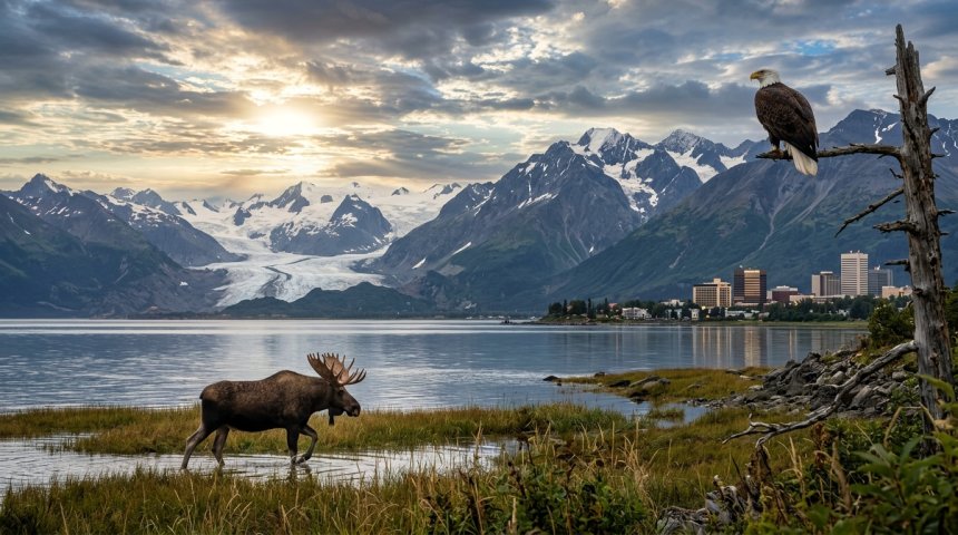
Alaska contains nearly forty percent of its entire state population within the single geographic hub of Anchorage and the neighboring Kenai Peninsula. When the Alaska Department of Labor and Workforce Development recorded population estimates for July 1, 2025, the Anchorage Municipality accounted for 289,221 residents while the Kenai Peninsula Borough held 61,327 residents. Combined, these two interconnected regions house roughly 47 percent of the state's total 738,737 residents. This part of southcentral Alaska blends high-density urban infrastructure, major aviation and shipping terminals, and vast wilderness zones that stretch from deep tidewater fjords to alpine glaciers.
Analyzing this region involves studying geography, human history, and economic patterns. Encompassing the traditional homelands of the Dena’ina Athabascan people and modern municipal boundaries spanning thousands of square miles, Anchorage and the Kenai Peninsula act as the main entry points for studying southcentral Alaska.
Geographic Overview of the Anchorage Municipality
The Anchorage Municipality covers more than 1,700 square miles of diverse terrain, stretching from the muddy tidal flats of Knik Arm and Turnagain Arm up to the jagged peaks of the Chugach Mountains. According to municipal history compiled by state authorities, the current administrative boundary was established in 1975 when the original City of Anchorage merged with the Greater Anchorage Area Borough. This consolidation created a unique administrative unit that functions simultaneously as a dense urban core and an expansive wilderness park.
Within this 1,700-square-mile area, urban neighborhoods blend directly into protected natural habitats. Chugach State Park alone encompasses nearly half a million acres along the eastern edge of the municipality, making it one of the largest state parks in the United States. Residents and visitors can step out of commercial districts and immediately access alpine trails, glacial valleys, and wildlife corridors frequented by black bears, moose, and Dall sheep.
The low-lying coastal areas along Cook Inlet experience extreme tidal fluctuations, often exceeding thirty feet. These massive tides shape the local shoreline, creating extensive silt flats that prevent large commercial ships from docking directly at downtown beaches, which necessitated the construction of the Port of Alaska.
Indigenous History and the Dena’ina Athabascans
Long before modern municipal borders were drawn or the port was constructed, Anchorage and its surrounding waterways belonged exclusively to the Dena’ina Athabascan people. Archaeological and historical records indicate that Dena’ina communities thrived throughout the region for centuries, relying on seasonal migrations of fish, game, and plant resources.
A prominent Dena’ina fish camp operated at the mouth of Ship Creek as early as 1915, anchoring a network of seasonal settlements along Cook Inlet and the Knik and Turnagain arms. Families gathered at these camps during summer months to harvest runs of king, silver, and sockeye salmon, preserving the catch to sustain themselves through harsh winter months.
The Native Village of Eklutna, located near the northern boundary of the Anchorage Municipality, represents one of the oldest continually inhabited Dena’ina settlements in the region. Today, the village preserves deep cultural traditions while participating actively in regional governance and land management. The cultural heritage of the Dena’ina is woven directly into the modern identity of Anchorage, influencing place names, art installations, and local community programs.
The Founding and Growth of Anchorage
The modern city of Anchorage traces its formal origin to 1915, when the federal government selected the site at Ship Creek as a construction camp and headquarters for the Alaska Engineering Commission. The commission was tasked with building the Alaska Railroad, a monumental infrastructure project designed to connect the interior mining districts with a viable ice-free port on the southern coast.
Tents and wooden shacks quickly multiplied along the bluffs above Ship Creek, creating a tent city that temporarily housed thousands of construction workers, engineers, and entrepreneurs. In July 1915, the federal government held a public land auction, selling off townsite lots and establishing the permanent street grid that still defines downtown Anchorage today.
As rail construction progressed toward Fairbanks, Anchorage transitioned from a transient construction camp into a permanent transportation and commerce hub. The completion of the railroad in 1923 secured the settlement's economic foundation. Throughout the mid-twentieth century, the establishment of major military installations—including Elmendorf Air Force Base and Fort Richardson—brought rapid population growth and cemented the city's strategic importance during the Cold War.
The 1964 Great Alaska Earthquake
The resilience of Anchorage faced a major test on March 27, 1964, when a magnitude 9.2 earthquake struck southcentral Alaska. As documented by historical preservation records from the Alaska Department of Natural Resources, this seismic event remains the largest recorded earthquake in North American history and the second-largest earthquake ever measured worldwide.
The ground shook violently for nearly five minutes, triggering massive landslides, structural collapses, and tsunamis that devastated coastal communities across the region. In Anchorage, entire residential blocks along the Fourth Avenue downtown business district dropped several feet as subsurface clay layers liquefied. Turnagain Heights experienced catastrophic landslides that swept residential homes down into Cook Inlet.
Despite widespread destruction and loss of life, the city recovered quickly. Engineers, municipal leaders, and residents united to rebuild damaged infrastructure, implementing strict building codes and modern seismic safety standards that established Anchorage as a center for earthquake engineering and disaster preparedness.
Economic and Transportation Center of the State
Today, Anchorage functions as the undisputed economic and logistical engine of Alaska. The state government notes that Anchorage contains nearly forty percent of Alaska's population, making it the primary consumer market, labor pool, and service center for the entire state.
The Ted Stevens Anchorage International Airport serves as a global aviation powerhouse, ranking among the busiest cargo airports in the world due to its strategic midpoint location on great-circle routes connecting North America with Asia. Freighter aircraft constantly land and depart around the clock, refueling and transferring goods that supply communities throughout rural Alaska and the Lower Forty-Eight.
In addition to aviation, the Port of Alaska handles the vast majority of all freight entering the southcentral and interior regions, including construction materials, food, fuel, and manufactured goods. Financial institutions, regional healthcare providers, corporate headquarters, and tourism agencies are all concentrated within the municipal borders, providing employment for tens of thousands of workers across diverse economic sectors.
Transitioning South to the Kenai Peninsula
Traveling south from Anchorage brings visitors across the dramatic ridgeline of the Kenai Mountains and into the Kenai Peninsula Borough. Spanning an immense area, the Kenai Peninsula is approximately 200 miles long and 100 miles wide. According to geographic data from the U.S. Census Bureau, the borough encompasses 16,017.42 square miles of land.
Despite its massive geographic footprint, the Kenai Peninsula maintains a sparse population density. The 2020 Census recorded 58,799 residents, resulting in a density of just 3.7 residents per square mile. Official estimates from the Alaska Department of Labor and Workforce Development indicate steady growth, with the borough population reaching 61,327 residents by July 1, 2025.
The peninsula features diverse geography, containing every major Alaska wildlife habitat type except Arctic tundra. Drivers on the Seward Highway or the Sterling Highway pass through dense spruce forests, wetlands, coastal mountains, active volcanoes across Cook Inlet, and massive icefields feeding dozens of tidewater glaciers.
Early Human History on the Kenai Peninsula
Human occupation of the Kenai Peninsula extends back thousands of years before written history. Archaeological excavations along the banks of the Kenai River have uncovered sites dating back 8,000 to 10,000 years, revealing how early nomadic hunter-gatherers utilized the rich glacial valleys for survival.
Intensive salmon fishing and permanent settlement patterns began to emerge at least 2,000 years ago. Riverine Kachemak and later Kenaitze Dena’ina communities established sophisticated fish-weir systems and seasonal villages along the lower reaches of the Kenai and Kasilof rivers, sustainably harvesting massive runs of migrating salmon.
These indigenous groups maintained extensive trade networks extending across Cook Inlet and into the interior plateaus. Their descendants continue to steward the land, maintaining deep cultural ties to the rivers, forests, and marine ecosystems that have sustained generations of families on the peninsula.
Russian Exploration and Settlement
The arrival of European explorers in the eighteenth century introduced sweeping changes to the Kenai Peninsula. Russian fur traders, pushing eastward across the Pacific in search of valuable sea otter pelts, arrived along the Alaskan coast in 1741.
By 1791, Russian fur traders established a permanent settlement and fur-and-fish trading post at present-day Kenai, known historically as Fort St. Nicholas. This outpost allowed the Russian-American Company to exert control over local indigenous populations, forcing Aleut and Dena’ina hunters into service for the lucrative maritime fur trade.
The Russian presence left lasting historical and cultural markers across the peninsula, notably in historic Russian Orthodox churches with distinctive onion domes. Communities like Kenai and Ninilchik retain descendants of early Russian settlers and indigenous families, preserving linguistic and cultural traditions that reflect this colonial history.
The Kenai River Special Management Area
The Kenai River is a prominent sportfishing destination, drawing anglers from around the world. To protect this aquatic habitat from recreational pressure and degradation, the State of Alaska established the Kenai River Special Management Area in 1984.
Managed by the Alaska Department of Natural Resources, this protected zone encompasses more than 105 linear miles of river and connected lakes, including Kenai Lake and Skilak Lake. The management area is designed to balance public recreational access with rigorous conservation practices, protecting critical spawning grounds for chinook, sockeye, coho, and pink salmon.
Strict regulations govern boat speeds, fishing gear, bank access, and habitat restoration projects along the riverbanks. Elevated boardwalks and viewing platforms have been installed at popular access points to prevent shoreline erosion and protect the delicate riparian vegetation that shades the water and stabilizes the banks.
World-Record Fishing Heritage
The legendary status of the Kenai River was cemented in global fishing lore in 1985, when an angler landed the world-record king salmon—a massive fish weighing 97 pounds and 4 ounces. While subsequent decades have seen shifts in run sizes and conservation challenges, the river continues to produce exceptionally large king and sockeye salmon.
Sportfishing on the Kenai Peninsula is a major economic driver, supporting a vast network of guiding businesses, lodges, tackle shops, and charter boat operators. During the peak summer runs, thousands of visitors line the riverbanks or anchor drift boats in the emerald-green current, participating in an annual ritual that defines the summer season in southcentral Alaska.
Commercial and subsistence fisheries operate throughout Cook Inlet and local coastal waters, providing employment and food security for households. Managing these user groups requires ongoing scientific research and oversight by state and federal fisheries biologists.
Communities of the Kenai Peninsula
The Kenai Peninsula Borough is home to a collection of distinct communities, each with its own character, economic base, and history. Soldotna serves as the central administrative hub and retail center for the peninsula, situated near the banks of the middle Kenai River.
Just downstream sits the city of Kenai, combining historic Russian heritage with modern industrial activity tied to natural gas extraction, commercial fishing, and oil refining. Kenai features sweeping views across Cook Inlet to active volcanoes like Mount Redoubt and Mount Spurr on the western horizon.
Further south, Homer is widely celebrated as the "Halibut Fishing Capital of the World." Famous for the Homer Spit—a narrow, 4.5-mile gravel bar jutting out into Kachemak Bay—the town attracts artists, commercial fishermen, outdoor enthusiasts, and travelers seeking marine adventures. Kachemak Bay provides sheltered waters teeming with marine mammals, seabirds, and rich tidepool ecosystems.
On the eastern side of the peninsula, Seward functions as the southern terminus of the Alaska Railroad and the Seward Highway. Located at the head of Resurrection Bay, Seward provides access to Kenai Fjords National Park, where tidewater glaciers calve icebergs directly into ocean waters.
Tourism and Outdoor Recreation
Tourism drives the economy for both Anchorage and the Kenai Peninsula. Visitors arriving through Anchorage international flights frequently rent vehicles or board the coastal train to explore the southern wilderness.
Outdoor recreational opportunities are virtually limitless. Hiking trails wind through the Chugach Mountains, climb alpine ridges overlooking turquoise glacial lakes, and lead to secluded backcountry cabins maintained by state and federal land agencies. Sea kayaking in Resurrection Bay or Kachemak Bay allows paddlers to approach floating ice, harbor seals, sea otters, and soaring bald eagles.
Winter tourism brings distinct activities, turning the area into a venue for cross-country skiers, snowmobilers, dog mushers, and backcountry snowshoers. Anchorage hosts major winter events, including the ceremonial start of the Iditarod Trail Sled Dog Race every March, drawing spectators to downtown streets.
Climate and Environmental Dynamics
The climate of Anchorage and the Kenai Peninsula is subarctic, tempered by maritime influences along coastal zones. Winters bring cold temperatures and snowfall, while summers are mild, featuring long daylight hours that encourage rapid plant growth and floral blooms.
Environmental changes present ongoing challenges and areas of study for scientists working in the region. Glaciers across the Kenai Mountains exhibit varying rates of recession, impacting freshwater hydrology, salmon habitat temperatures, and downstream sediment loads. Coastal erosion along Cook Inlet affects local infrastructure, requiring adaptive management strategies from municipal and borough planners.
Forest health has also faced severe pressures from insect infestations, particularly outbreaks of spruce bark beetles that have impacted thousands of acres of spruce forests across the Kenai Peninsula. State forestry agencies actively monitor these insect populations and manage timber stands to reduce wildfire risks near populated communities.
Infrastructure and Connectivity
Connecting Anchorage and the Kenai Peninsula requires a resilient and well-maintained transportation network. The Sterling Highway serves as the primary ground artery linking Anchorage to Soldotna, Homer, and the central peninsula, branching off from the Seward Highway just south of Turnagain Arm.
Recent engineering projects, such as the Sterling Highway Anchor Point Improvement Project managed by the Alaska Department of Transportation and Public Facilities, have realigned roadways and constructed modern bridges to improve safety, reduce congestion, and withstand challenging geotechnical conditions.
Rail transport remains an active link, with the Alaska Railroad operating passenger excursions and freight services between Anchorage, Seward, and Talkeetna. These rail lines provide travelers with views of remote wilderness areas inaccessible by standard automobile roads, supporting tourism and regional logistics.
Future Outlook for Southcentral Alaska
As Anchorage and the Kenai Peninsula look toward the coming decades, community leaders balance economic growth with environmental conservation and cultural preservation. Population trends indicate steady, moderate growth, with families and professionals drawn to the region's unmatched quality of life, outdoor recreation, and economic opportunities.
Infrastructure modernization, renewable energy projects, and resource management will shape the future of the Anchorage Municipality and the Kenai Peninsula Borough. By respecting the heritage of the Dena’ina Athabascans, protecting environments like the Kenai River, and maintaining transportation networks, southcentral Alaska honors its past while preparing for coming decades.
What is the population of Anchorage and the Kenai Peninsula?
According to population estimates released by the Alaska Department of Labor and Workforce Development for July 1, 2025, the Anchorage Municipality had 289,221 residents, while the Kenai Peninsula Borough had 61,327 residents. Together, these two regions account for approximately 47 percent of Alaska's total population.
When was Anchorage founded?
Modern Anchorage was founded in July 1915 following a federal land auction held by the Alaska Engineering Commission. The commission had selected the site at Ship Creek earlier that year as the construction headquarters for the Alaska Railroad.
What caused the 1964 earthquake in Anchorage?
The 1964 earthquake was a magnitude 9.2 megathrust earthquake that struck southcentral Alaska on March 27, 1964. It remains the largest recorded earthquake in North American history, causing widespread soil liquefaction, structural damage, and major landslides in Anchorage.
Why is the Kenai River famous?
The Kenai River is internationally renowned for its massive runs of king and sockeye salmon. It holds the world record for the largest sport-caught king salmon, a 97-pound, 4-ounce fish caught in 1985. The river is strictly managed under the Kenai River Special Management Area to protect critical fish spawning habitats.
What indigenous people traditionally inhabited the Anchorage area?
The Anchorage region and surrounding waterways are the traditional homelands of the Dena’ina Athabascan people. Historic and archaeological sites include ancient seasonal fish camps along Ship Creek and permanent settlements such as the Native Village of Eklutna.
How large is the Kenai Peninsula Borough?
The Kenai Peninsula Borough covers 16,017.42 square miles of land. The peninsula itself is approximately 200 miles long and 100 miles wide, containing diverse wildlife habitats ranging from coastal fjords and spruce forests to massive glacial icefields.
Economic Foundations and Regional Industries
The economies of Anchorage and the Kenai Peninsula rely on a mix of industries that use the natural resources, location, and scenery of southcentral Alaska. Anchorage acts as the financial, corporate, and logistical center of the state. Its position as an air cargo hub connects North America with Asia, while downtown office towers house headquarters for oil and gas corporations, Native regional corporations, and government agencies. This urban commercial center provides professional services, health care, and educational infrastructure supporting outlying regions across the state.
Moving south across Turnagain Arm, the economic focus shifts toward resource extraction, commercial fishing, tourism, and outdoor recreation. The Kenai Peninsula has a history of oil and gas development, particularly around Kenai and Soldotna, where onshore and offshore fields have operated for decades. Refineries and natural gas processing plants contribute to local employment and municipal tax revenues, balancing seasonal fluctuations in visitor-driven industries. Commercial fishing is another base of the peninsula’s economy. Fleets operating out of Homer, Kenai, and Seward harvest millions of pounds of salmon, halibut, cod, and shellfish annually, supplying domestic and international seafood markets.
Small businesses, hospitality providers, and outfitters thrive throughout the borough. Because nearly half of Alaska's population resides within the combined footprint of Anchorage and the Kenai Peninsula, internal trade and consumer services remain active year-round. Public sector employment—including military personnel at Joint Base Elmendorf-Richardson in Anchorage, municipal workers, and land management agencies—stabilizes the regional economy. As global markets evolve and environmental standards shift, both municipalities invest in workforce development, energy efficiency, and infrastructure upgrades to maintain long-term economic stability.
Conservation, Land Management, and Public Access
Managing public lands and protecting ecosystems across Anchorage and the Kenai Peninsula is a responsibility shared by municipal, state, and federal agencies. Because the region encompasses over 17,000 square miles of geography—ranging from urban parks in Anchorage to alpine tundra, deep fjords, and icefields on the peninsula—coordinated stewardship is necessary to balance public access with environmental preservation.
Federal and state entities, including the Alaska Department of Natural Resources, manage vast tracts of public land to safeguard wildlife corridors, recreational areas, and critical habitats. On the Kenai Peninsula, protected zones like the Kenai River Special Management Area ensure that high-impact recreational activities do not compromise water quality or salmon spawning beds. Similar protections apply to coastal marine environments, where state parks and national parks safeguard tidewater glaciers, marine mammal breeding grounds, and pristine bays.
Community involvement shapes local conservation efforts. Watershed councils, volunteer groups, and Native organizations collaborate with government agencies on stream restoration projects, invasive species removal, and trail maintenance. These partnerships help mitigate the impacts of climate change, tourism pressure, and urban expansion. By fostering shared responsibility, Anchorage and the Kenai Peninsula maintain the ecological integrity and natural beauty that define southcentral Alaska for future generations.
Share
What's Your Reaction?
 Like
0
Like
0
 Dislike
0
Dislike
0
 Love
0
Love
0
 Funny
0
Funny
0
 Angry
0
Angry
0
 Sad
0
Sad
0
 Wow
0
Wow
0